
Coodinates: 51°00′ South 73°06′ West
Right from the beginning of my trip I’d been harbouring the idea of visiting Torres del Paine, the famous national park in Patagonia in the far south Chile. Part of my initial trip to the south had been with that destination in mind but by the time I’d spent a month in Bariloche and March was marching by, I knew I would have to delay or risk some very poor weather. Rather than make my way south from Bariloche and El Bolsón, through to El Chaltén, El Calafate and eventually Puerto Natales – the gateway to the Torres del Paine – I booked a flight for Buenos Aires and left the far south for another voyage.
Before my trip I would have been frantically planning, organising groups and packing too much stuff for the trek in the national park but by now I knew that this was:
a) pointless
b) difficult
c) likely to change anyway
You just can’t coordinate effectively with groups who have different schedules after the semester unless you’re all part of the same program. I also don’t have Facebook so spur of the moment gatherings and organising isn’t possible for me through that channel, it’s a price I pay for not being part of that social cluster-frak but one I decided to pay years ago. I was gonna wing it.
I did wing it from Santiago to Punta Arenas and on the flight I met by chance Paulette, also from la Católica and participant in the CAUC program of activities for primarily foreign students doing exchange at the uni. I’d spent a day falling over in the snow with her at the beginning of the semester. She told me she was going to meet a group who were waiting to do the trek in Torres del Paine. After boarding in a hot and sunny Santiago, we stepped off the plane in a cold and overcast Punta Arenas airport to be greeted by drizzle and six degrees. Yes sir, you’ve arrived at 51 degrees south.
Fortune flowed and we were soon picked up by the bus which left us in Puerto Natales where a lady approached us offering accommodation for CL5000 (AUD10.50) – apparently half price without the breakfast – which we accepted. We were leaving at 7:30am the next morning for the national park, some 120kms away. The ride took about 3 hours in which good fortune once again manifest itself at the park entrance, where as a student with a Chilean identity card I was charged the discount ‘Chilean’ price, less than a third the price foreigners pay for entrance. From where the bus dropped us off, we took a ferry to the camping ground where we were going to start the four day trek in the national park.
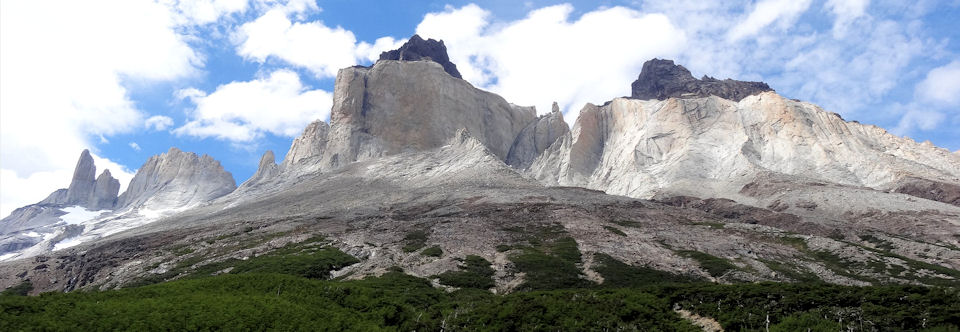
The Torres del Paine national park is a protected wilderness area in the Magallanes region of the Chilean Patagonia. In 2012 it was named the 8th Wonder of the World for its extraordinary rock formations carved out by glaciers some 12 million years ago. It is a standalone cluster of mountains that stand alone, separated from the Andes and can be seen in its imposing majesty for many kilometres in all directions, sometimes resplendent beneath clear skies but often shrouded in mysterious vales of cloud which cling to the escarpments or weave their way through the valleys. It is very Middle-Earth-esque when wrapped in cloud as it was on the day we arrived and watched its frozen peaks appear and disappear behind a mantle of cloud. It is a wild place of glaciers, cold-climate forests, lakes of glacial melt, guarded by rocky turrets and ruled by fierce winds. It is the habitat of Condors and Pumas and other distinct flora and fauna. It’s recent elevation to the status of ‘World Wonder’ has made it Chile’s most popular tourist destination where droves of kitted Europeans, Americans and Israelis sporting technical gear from the likes of North Face, Columbia, Scarpa, Marmot, Asolo and Doite pick their way to the campsites and refuges throughout the park. The two most popular ways to ‘do the Torres’ is the 8-day ‘O’ walking the circumference of the park, and the 4-5 day ‘W’ – done east to west or visa versa – which is the more popular front end tour of the popular spots including Glaciar Grey, Valle Francés, and Las Torres (The Towers). See the map before for and idea of configuration of the park and how we did it.


Had I known I was chaperoning a damsel to the arms of her newfound sweetheart I may have rethought the likely eventuality of being third wheel to a romantic duet. I could have also read the signs: young woman travels 2,000kms on the spur of the moment, still bleary eyed from exams to meet and group who were ‘waiting’ to do trekking near the end of the world. I can think of only four reasons a person would do this:
1) A truly intrepid spirit
2) Romance
3) Death in the family (or equivalent)
4) Financial Incentive
Paulette seemed glad to have someone to accompany her on that leg of the journey and I was greatful to have found what I thought I was looking for; a group of familiar faces with whom I’d trekked with before and had the gear I lacked. I didn’t have a tent or cooking stove and by the time the romantic nature of the trip became apparent to me I’d passed the exit so to speak and had to stay with the group which thankfully consisted of another person – who became equally disenchanted by the prospect. Personally, I think it is a great thing to do together, to go trekking and camping in some marvellous place like Torres del Paine but it can mess with a group’s dynamic if some members were not expecting it. Eventually Jerome, the other wheel, and I went on ahead and left the lovebirds to themselves.
Glaciar Grey was for me my first real view of a glacier and I was impressed by the size – though first seen from further off – of this mass of ice. Its frozen walls flanked an island in the middle of the lake while the remains disappeared far up the valley to distant snow-covered mountains. Icebergs floated in the glacial melt and glowed with an eerie blue that at first seems unrealistic but which at least seems to explain why glacial lakes are that characteristic light-blue colour! A freezing wind was blowing and the day was undecided with droplets of rain and patches of blue sky each fighting for dominance. An icy slush lined the shores of the lake where low, climate-toughened, wind-shredded vegetation clung to the rocks strewn over the lower slopes of the mountains which rose up steeply from the bay to a realm of eternal winter where a dusting of snow was visible on the rocky peaks. In the folds of the valleys and the more protected slopes trees flourished, but these were the climate toughened Lenga trees common to southern Chile and Argentina.
Day one was the a there and back to Glaciar Grey, on day two we moved camp, walking two and a half hours to Campamento Italiano at the beginning of the Valle Francés. The walk to the lookout beyond Campamento Británico took about four hours of slow climbing with many stops to take in an increasingly impressive vista. In the background the sounds of a glacier cracking and creaking crashed like thunder from time to time followed by a small ice-flow that was completely disproportional to the impressive sound which echoed off the mountains all around as though heralding some massive rending of ice and rock in the snowy heights with chunks of glacier weighing many tons hurtling down from the heights before smashing on the lower slopes and plunging into the water. Sounds and writing are in my opinion the best fuel for the imagination. From the lookout the view is singular. Sheer rock faced escarpments surround the valley on three sides with the more classic snow capped mountain peaks as well as the spectacular rocky towers which thrust skyward to contend with the almost perpetual catabatic winds which raged at the higher altitudes. The fourth side led back down the valley lined by a carpet of Lenga forest marching away into the distance to the glacial lakes spread out below and yet more snow capped mountains visible behind the blue curtain of the far distant background.


Day three was a 25km hike with the backpack to the campsite below the Torres themselves. The walk down to Los Cuernos was a pleasant descent through the trees and undergrowth and natural clearing down the shores of Lake Nordenskjold where the wind rose to gale force and began to throw me around. What the day before had been a serene blue lake had now been whipped into a frenzy by the wind and from above water could be seen been lifted from the surface of spume crested wavelets. From Los Cuernos to Campamento Chileno the wind remained strong as we passed along the exposed and elevated lower slopes. At time the wind would throw you bodily (backpack and all) it was so strong, particularly in gusts where grit from the path was thrown in your eyes causing you to wince, squint and spread your feet wide for stability. I had never experienced such strong wind and am only grateful it wasn’t also carrying rain! Rounding the bluff the wind remained strong only the path became narrow and the slope dropped away steeply down to the river gorge below. The valley narrowed as we descended toward the Campamento Chileno where we sheltered amongst the rocks beside the river and ate our lunch. For the leg from Cuernos I’d been walking with a group of Americans who were completing the entire ‘O’ circuit and were on their seventh day. Tired, and feeling the onset of a sore throat I was eager to reach the camp and the last hour and a half couldn’t pass quickly enough, despite passing through beautiful sheltered forest before Las Torres, which had been visible above the cliffs for some time.


The plan was to get up before sunrise, walk for 45 minutes up the steep rocky slope and wait by the sides of the small lake for the first rays of the sun to touch the tops of the Torres. Many took their sleeping backs which made good sense to stave off the freezing wind which sucks the heat out of you and makes sitting and waiting a tortuous prospect. Eventually the sun did great the peaks and out came the cameras and the forced smiles for the happy postcard shots to capture the moment, without the wind, as souvenirs for years to come. Slowly the light changed and so did the mood of the inhospitable surroundings. The rock of the Torres changed imperceptibly from orange to a lighter shade and eventually to a white while the shadow line descended the rocky heights. I was glad to have seen the Torres free of cloud but soon the cold was too much and I decided to descend back to the camp were I huddled back into my sleeping bag until Jerome declared his intention to make the 2:30pm bus back to Puerto Natales and as it was his tent I was left to sit on my bag, beneath a tree blinking in the morning light as I prepared to face the day.


In no hurry, I tarried, going for a small walk to another mirador (lookout) nearby the campsite to see the Torres, which were now covered in cloud, from another angle. Afterwards I hung around with Jerome’s Spanish friends from Osorno and walked back with them to laguna amarga where the 7:45pm bus would leave from. Walking back along the road was difficult for sore feet and a tired body, but it provided good closure to the whole experience as I watched the Torres rising impressively from the undulating hills which surrounded them retreat into the mid ground, their peaks once again wrapped mysteriously in cloud as they had been the day I arrived. Despite fierce winds and a times a biting cold, I count myself lucky to have seen what I did without driving rain which would have lessened the sheer majesty of the setting and was a misfortune which had beset many a traveller I later spoke to.