
I deferred northward travel from Cusco, preferring to remain in the city an extra week exploring further the winding streets, restaurants and activities – one of which didn’t happen, and the other of which was not worth it – but I still enjoyed myself immensely.
Arequipa is another tourist destination in southern Perú and I passed through it, staying a few days, on my way south to Santiago to begin studying. A plush overnight bus from Cusco left me without one night’s sleep, blinking in the early morning light. As with Cusco, the central part of the city is the tourist attraction, with old buildings built of a light volcanic rock, a walled monastery and elegant main square. Just as in Cusco, the bus terminal is nowhere near the centre of town, a requirement for maintaining a lucrative taxi industry to which I have paid my dues. Apart from an expensive French creperie, some expensive fine-dining restaurants lining the cities popular pedestrian walkway, an elegant colonial style main square and building and a wonderful (and typical) Peruvian market, I really didn’t see much of the city, being present and conscious just one afternoon and two evenings.


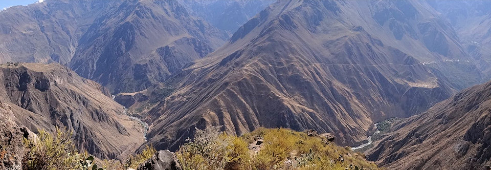
Most come to Arequipa to see the Colca Canyon, which isn’t near the town but some 150kms northward, in the direction of Cusco. The canyon is quite long, beginning in Chivay and continuing north-westward past the town of Cabanaconde 60kms distant. Tourism used to be higher they say, before the Colca Valley authority doubled the tourist ticket entry price to S/. 70, S28 but my bus was full. The most trodden paths into the Colca Valley begin and end in Cabanaconde, but just before arriving I got off the bus to see the condors at the Cross of the Condors lookout. Every morning these majestic creatures rise from their nests further down in the valley, floating upward on the thermals to wheel in the skies high above the valley. Between the hours of 7:30am and 10am the condors can be seen from the lookout soaring effortlessly around the upper reaches of the canyon. In the background the far wall of the canyon rises upward to above 5,000 meters, resting above the cloud and below the sky in a series of jagged, snow capped peaks while their steep slopes fall away, leading the eye down to the tiny river snaking its way through the gorge far below. That was my road, and it began 14km further up the road in Cabanaconde.
Cruz del Condor


I planned to spend three days and two nights in the Canyon, walking to San Juan de Chuccho on the first afternoon, resting there for the night and continuing on to the oasis the following day. The track didn’t begin in the town, so I followed the road up to the plateau marked by a recently built stone museum. Here I left the road and walked along the side of a football field, keeping it on my left until I saw the lookout that marked the beginning of the trail. The descent into the valley was well market and easy to follow, but steep and hot in the midday sun. My map, a photocopy of a sketch of the valley rendered in colourful crayon, told me it would take 4 hours to reach San Juan de Chuccho but I soon realised these estimates were conservative. In 1 hour 20 minutes I had reached the bridge at the bottom of the valley and another twenty and I was in the little town. I should have learned from this overestimation on behalf of the information I had when I set out the next day for the Oasis down in the valley below Cabanaconde. It was supposedly a three hour walk but I was already descending the winding path after one and a half hours. Let me just say I’m not fitness freak with a chip on his shoulder and I would say that anyone in decent shape would find the time estimates overly generous.


I didn’t want to finish my days walk before midday so I doubled back with the intention of taking the higher road that led on to Llawar, then double back through the canyon by crossing the river and passing these geysers I had seen on the map. It was a long walk along the upper ridge and then winding down the slope on the other side but I hadn’t learned my lesson and mistakenly identified markers and small towns on the map as further than they actually were. So I passed by the turnoff to Llawar (which by the way is a tiny hamlet somewhat hidden behind the cliff above the river where it joins a tributary). I did find the geysers though, so I knew more or less where I was. Of course I also had my GPS so technically I knew exactly where I was but these little towns which appeared on my paper maps didn’t appear on my digital map so I had no way to reference myself using only the GPS. The small track marked on the map which led from the geysers back through the river gorge and approached the Oasis from the other direction was also visible along the side of the hill above the river. Down below steam rose from the rocky banks and in places the river itself was boiling. I went down and walked among the geysers before resuming my climb along the path. The going was difficult, steep and rocky and the path was narrow and the slope fell away steeply to the left. And then it just ended. Half way up the slope, half way round the gorge and with absolutely no possibility of continuing. It looked as though a land slide and erased a good section of the path and the only remaining exit was back the way I’d come.
By this time it was 3:30pm and I’d been walking for 6 hours. To walk all the way back would mean I’d be descending in the dark and with little remaining water for the trip. I decided instead to aim for Llawar which unknowingly I had already passed but maintained that it was around the bluff on the other side of the ridge and thus set out. I walked for another hour, conscious of my now lack of water, the non-appearance of my destination and what also appeared to be a vertical distancing from the river now some 400-500 meters straight down the slope. What to do? Food was no problem, nor was clothing, but the lack of water was a very real problem. Priorities abruptly changed and I resolved to ask anyone I saw for help. As a last resort (and one begins thinking in such terms) I could descend to the river though it would be a long hard descent and quite dangerous. With a GPS position (in which at least Cabanaconde appeared, though it was not in the same place as my paper maps) I deduced I had overshot and was now off the edge of the map. I lowered my walking speed and began breathing only through my nose. I was carry water purification pills so I didn’t have to be fussy. I cleared the bluff and my heart sank as I saw the road continued to wind it way upwards over the hill. There were no dwellings and no people. I kept walking and eventually saw a ramshackle shelter in the middle of a paddock up ahead and off to the right. I crossed what looked to be an ephemeral stream which was completely dry. Breaking from the path I crashed my way over to the shelter only to find it deserted. Inside was a rustic bed sitting on a dirt floor and hallelujah a large container of water – but the colour was a bid interesting. It looked a pale yellow and when I took off the lid I could see the micro-flora floating around. Strangely, the water had no odour, it smelled completely fine. Reassured I poured it into my own bottle (2.5 litres) none to elegantly and then added purification pills sufficient to treat 3 litres. Now I had to wait because I was not going to take chances with water that colour. I’d been in Bolivia some weeks before and knew about stomach bugs. Mouth dry and head pounding I marked the time on my phone and waited a full half hour before finally drinking – only a mouthful at a time for the next fifteen minutes. Never in my life had I been so thirsty, or had water tasted so good, so unbelievably good as it did in that moment seated on the bed in a makeshift shelter in the middle of nowhere.
View Trek in the Colca Canyon in a larger map
Afterwards I had something to eat before shouldering my pack for what would now be another long haul back to Cabanaconde along the dirt road winding away over the hill. I was resolved to arrive in the dark but it would be outside the canyon and therefore not so dangerous, just tiring. I learned a pretty important lesson about planning there, the importance of water, correct advice and accurate maps as well as the ability to extrapolate that if milestones had consistently been much shorter than stated, that this would apply to the rest of the milestones and distances stated.
Don’t get me wrong, the views were spectacular, quite stark and steep and memorable but just that towards the end of my second day they were not my primary focus. I did eventually get passed by someone on a motorbike who gave me a lift all the way back to Cabanaconde for which I was very grateful. The next day I walked to the looked outside the town which gave a spectacular view of my entire trek. Had I visited it first I would have known that Llawar was hidden somewhat behind the steep banks of the tributary river, I would have seen the correct, more direct path to take from the river crossing back up to Cabanaconde that I had missed the day before because I didn’t know to look for it thinking I was not yet there. I would also have known that the track through the gorge had been covered in a landslide because it was all visible from the lookout. I shot a video in which I describe the course of events and it will help all those reading to gain the perspective and thus understand how this all came about. Quite and experience. Needless to say, that night I slept pretty well!